About Echo Mountain Trail
Description
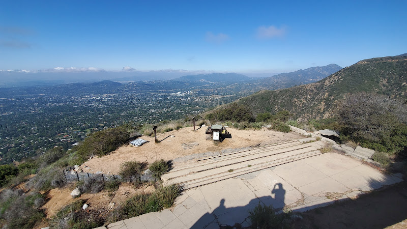
Look, I've hiked plenty of trails around LA, but there's something special about Echo Mountain that keeps drawing me back. [The ruins of the old Mount Lowe Railway at the summit](https://myfavoritehikes.wordpress.com/2010/11/15/echo-mountain/) tell silent stories of LA's golden age, and honestly, that's just part of what makes this hike so dang memorable. I did this trail last weekend (yes, again!) and I'm still buzzing from the experience. This [5.8-mile round trip hike is both a solid workout and a fantastic way to escape the city bustle](https://hikingguy.com/hiking-trails/los-angeles-hikes/echo-mountain-hike-on-the-sam-merrill-trail/). You'll gain about 1,400 feet in elevation, which yeah, will definitely get your heart pumping, but trust me - those panoramic views of LA Basin make every sweaty step worth it.Key Features
• Historical ruins of the Mount Lowe Railway - these aren't your ordinary ruins, folks. We're talking about remnants of what was once called "The Railway to the Clouds" • Sweeping views of the San Gabriel Valley and Los Angeles Basin • Well-maintained Sam Merrill Trail with clear markers • Multiple scenic viewpoints along the way • Natural California chaparral landscape • Picnic areas near the summit • Interpretive signs explaining the area's fascinating history • Echo-testing spot at the top (c'mon, you know you want to try it!)Best Time to Visit
I've done this hike in pretty much every season, and here's the real talk: early morning or late afternoon are your best bets. The trail gets pretty exposed, and that California sun can be brutal. Winter and spring are particularly magical - you get clearer views of the city, and if you're lucky, you might catch some wildflowers showing off along the trail. Weekends tend to get crowded (I mean, it is one of LA's favorite hikes), so if you can swing a weekday visit, you'll have a more peaceful experience. And here's a pro tip: foggy mornings can make for some absolutely epic photos when you break through the marine layer at the top.How to Get There
The trailhead starts at the north end of Lake Avenue in Altadena. You'll find street parking along Lake Avenue - just keep an eye out for any parking restrictions. The Sam Merrill trailhead is pretty obvious once you reach the end of Lake Avenue, with a clear sign marking the start of your adventure. If you're taking public transit, you can catch the Metro bus to Lake Avenue and then walk north to the trailhead. Just remember to pack enough water because once you start, there's no turning back for supplies!Tips for Visiting
Listen, I've learned these lessons the hard way so you don't have to. First off, bring more water than you think you need - at least 2 liters per person. The elevation gain is no joke, and the trail offers very little shade. A hat and sunscreen are absolute must-haves, even on cloudy days. Start early if you can - like, sunrise early. Not only will you avoid the heat, but you'll also get some killer photo ops. Pack a snack to enjoy at the top while you explore the ruins. And speaking of ruins, bring a flashlight if you plan to peek into some of the old foundations (just watch your step). The trail can get pretty rocky in spots, so wear proper hiking shoes. Those cute fashion sneakers? Save 'em for the post-hike coffee run. And don't forget to download an offline map before you head out - cell service can be spotty on parts of the trail. If you're bringing kids along (and yes, this trail is totally doable with older kids), make it fun by turning it into a history lesson. There are plenty of cool stories about the old railway and hotel that once stood at the top. Finally, keep an eye on the weather forecast. While Southern California is usually pretty predictable, this trail can get sketchy after rain, and nobody wants to deal with loose soil on those switchbacks. Trust me on this one - I once tried to tough it out after a storm and let's just say it wasn't my proudest hiking moment. Remember to pack out what you pack in - this trail is a local treasure, and we all need to do our part to keep it that way. And hey, if you're feeling energetic at the top, you can always continue on to Inspiration Point for even more spectacular views. But that's a story for another day!Description
Look, I’ve hiked plenty of trails around LA, but there’s something special about Echo Mountain that keeps drawing me back. [The ruins of the old Mount Lowe Railway at the summit](https://myfavoritehikes.wordpress.com/2010/11/15/echo-mountain/) tell silent stories of LA’s golden age, and honestly, that’s just part of what makes this hike so dang memorable. I did this trail last weekend (yes, again!) and I’m still buzzing from the experience.
This [5.8-mile round trip hike is both a solid workout and a fantastic way to escape the city bustle](https://hikingguy.com/hiking-trails/los-angeles-hikes/echo-mountain-hike-on-the-sam-merrill-trail/). You’ll gain about 1,400 feet in elevation, which yeah, will definitely get your heart pumping, but trust me – those panoramic views of LA Basin make every sweaty step worth it.
Key Features
• Historical ruins of the Mount Lowe Railway – these aren’t your ordinary ruins, folks. We’re talking about remnants of what was once called “The Railway to the Clouds”
• Sweeping views of the San Gabriel Valley and Los Angeles Basin
• Well-maintained Sam Merrill Trail with clear markers
• Multiple scenic viewpoints along the way
• Natural California chaparral landscape
• Picnic areas near the summit
• Interpretive signs explaining the area’s fascinating history
• Echo-testing spot at the top (c’mon, you know you want to try it!)
Best Time to Visit
I’ve done this hike in pretty much every season, and here’s the real talk: early morning or late afternoon are your best bets. The trail gets pretty exposed, and that California sun can be brutal. Winter and spring are particularly magical – you get clearer views of the city, and if you’re lucky, you might catch some wildflowers showing off along the trail.
Weekends tend to get crowded (I mean, it is one of LA’s favorite hikes), so if you can swing a weekday visit, you’ll have a more peaceful experience. And here’s a pro tip: foggy mornings can make for some absolutely epic photos when you break through the marine layer at the top.
How to Get There
The trailhead starts at the north end of Lake Avenue in Altadena. You’ll find street parking along Lake Avenue – just keep an eye out for any parking restrictions. The Sam Merrill trailhead is pretty obvious once you reach the end of Lake Avenue, with a clear sign marking the start of your adventure.
If you’re taking public transit, you can catch the Metro bus to Lake Avenue and then walk north to the trailhead. Just remember to pack enough water because once you start, there’s no turning back for supplies!
Tips for Visiting
Listen, I’ve learned these lessons the hard way so you don’t have to. First off, bring more water than you think you need – at least 2 liters per person. The elevation gain is no joke, and the trail offers very little shade. A hat and sunscreen are absolute must-haves, even on cloudy days.
Start early if you can – like, sunrise early. Not only will you avoid the heat, but you’ll also get some killer photo ops. Pack a snack to enjoy at the top while you explore the ruins. And speaking of ruins, bring a flashlight if you plan to peek into some of the old foundations (just watch your step).
The trail can get pretty rocky in spots, so wear proper hiking shoes. Those cute fashion sneakers? Save ’em for the post-hike coffee run. And don’t forget to download an offline map before you head out – cell service can be spotty on parts of the trail.
If you’re bringing kids along (and yes, this trail is totally doable with older kids), make it fun by turning it into a history lesson. There are plenty of cool stories about the old railway and hotel that once stood at the top.
Finally, keep an eye on the weather forecast. While Southern California is usually pretty predictable, this trail can get sketchy after rain, and nobody wants to deal with loose soil on those switchbacks. Trust me on this one – I once tried to tough it out after a storm and let’s just say it wasn’t my proudest hiking moment.
Remember to pack out what you pack in – this trail is a local treasure, and we all need to do our part to keep it that way. And hey, if you’re feeling energetic at the top, you can always continue on to Inspiration Point for even more spectacular views. But that’s a story for another day!
Location
Places to Stay Near Echo Mountain Trail
Find Tours in Altadena
Explore More Travel Guides
No reviews found! Be the first to review!

