About San Bruno Mountain State & County Park
Description
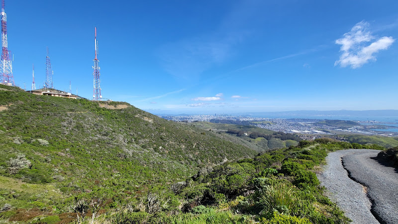
San Bruno Mountain State & County Park is a remarkable 2,416-acre natural refuge that stands as a breath of fresh air amid the bustling San Francisco Peninsula. Look, I've visited countless parks in the Bay Area, but there's something special about this one. The mountain reaches a height of 1,314 feet, rewarding visitors with those jaw-dropping panoramic views of San Francisco's skyline, the bay, and on clear days, you can even spot the Golden Gate Bridge peeking through the fog.Key Features
• 12 miles of diverse hiking, biking, and jogging trails catering to both beginners and experienced outdoor enthusiasts • Unique biodiversity with several endangered species that call this mountain their exclusive home • Picnic areas with tables scattered throughout, perfect for that post-hike lunch with family • Wide-open meadows that burst with wildflowers during spring • Multiple vista points offering different perspectives of the Bay Area • Natural habitat preservation zones protecting rare butterfly species • Educational interpretive center showcasing local flora and fauna • Well-maintained restroom facilities at the main entrance • Dedicated parking areas for visitorsBest Time to Visit
I've explored this park in all seasons, and let me tell you - spring is absolutely magical here. Between March and May, the mountainside transforms into a canvas of colorful wildflowers, and the weather is just perfect for hiking. That said, fall months (September to November) offer crystal-clear views of the bay, making it ideal for photography enthusiasts. Summer can get pretty foggy, especially in the mornings, but don't let that discourage you! The fog usually burns off by afternoon, and those cooler temperatures actually make for comfortable hiking conditions. Winter brings its own charm with green hillsides and fewer crowds, though some trails can get muddy after rain.How to Get There
Getting to San Bruno Mountain is surprisingly easy, considering its location in such a metropolitan area. The park sits conveniently between Highway 101 and Interstate 280. Ya know what's great? You can actually reach it using public transportation too! From San Francisco, hop on BART to the South San Francisco station, then catch the local bus that drops you right at the park entrance. If you're driving (which most folks do), you'll find the entrance just off of Guadalupe Canyon Parkway. Coming from either San Francisco or the Peninsula, you really can't miss it - the mountain itself serves as a natural landmark guiding you there.Tips for Visiting
Alright, let me share some insider tips I've learned from my countless visits here. First off, layer up! The weather can change quickly - I once started a hike in sunshine and ended it in thick fog. Bring a light jacket even on warm days. The Summit Loop Trail is probably the most popular (and my personal favorite), but if you're looking for something less crowded, try the Dairy Ravine Trail. It's a bit steeper but totally worth it for the solitude and unique views. Early mornings are best if you want to spot wildlife - I've seen coyotes, rabbits, and all sorts of birds during my sunrise hikes. Pack plenty of water because there aren't any water fountains once you're on the trails. And don't forget your camera - trust me, you'll want to capture those views! Parking can get pretty packed on weekends, especially after 10 AM. I usually aim to arrive by 8:30 AM to snag a good spot and enjoy the morning calm. Oh, and bring cash for the parking fee - while they're working on accepting cards, it's better to be prepared. If you're into botany or just curious about nature, spring brings some seriously rare wildflowers. Download a plant identification app before your visit - it's like going on a botanical treasure hunt! And speaking of preparation, check the weather forecast before heading out. The mountain creates its own microclimate, often different from surrounding areas. For first-timers, I'd recommend starting with the Summit Loop Trail - it gives you a great overview of what makes this park special without being too challenging. And don't rush! Take time to read the interpretive signs along the trails; they're full of fascinating information about the mountain's unique ecosystem and history.Description
San Bruno Mountain State & County Park is a remarkable 2,416-acre natural refuge that stands as a breath of fresh air amid the bustling San Francisco Peninsula. Look, I’ve visited countless parks in the Bay Area, but there’s something special about this one. The mountain reaches a height of 1,314 feet, rewarding visitors with those jaw-dropping panoramic views of San Francisco’s skyline, the bay, and on clear days, you can even spot the Golden Gate Bridge peeking through the fog.
Key Features
• 12 miles of diverse hiking, biking, and jogging trails catering to both beginners and experienced outdoor enthusiasts
• Unique biodiversity with several endangered species that call this mountain their exclusive home
• Picnic areas with tables scattered throughout, perfect for that post-hike lunch with family
• Wide-open meadows that burst with wildflowers during spring
• Multiple vista points offering different perspectives of the Bay Area
• Natural habitat preservation zones protecting rare butterfly species
• Educational interpretive center showcasing local flora and fauna
• Well-maintained restroom facilities at the main entrance
• Dedicated parking areas for visitors
Best Time to Visit
I’ve explored this park in all seasons, and let me tell you – spring is absolutely magical here. Between March and May, the mountainside transforms into a canvas of colorful wildflowers, and the weather is just perfect for hiking. That said, fall months (September to November) offer crystal-clear views of the bay, making it ideal for photography enthusiasts.
Summer can get pretty foggy, especially in the mornings, but don’t let that discourage you! The fog usually burns off by afternoon, and those cooler temperatures actually make for comfortable hiking conditions. Winter brings its own charm with green hillsides and fewer crowds, though some trails can get muddy after rain.
How to Get There
Getting to San Bruno Mountain is surprisingly easy, considering its location in such a metropolitan area. The park sits conveniently between Highway 101 and Interstate 280. Ya know what’s great? You can actually reach it using public transportation too! From San Francisco, hop on BART to the South San Francisco station, then catch the local bus that drops you right at the park entrance.
If you’re driving (which most folks do), you’ll find the entrance just off of Guadalupe Canyon Parkway. Coming from either San Francisco or the Peninsula, you really can’t miss it – the mountain itself serves as a natural landmark guiding you there.
Tips for Visiting
Alright, let me share some insider tips I’ve learned from my countless visits here. First off, layer up! The weather can change quickly – I once started a hike in sunshine and ended it in thick fog. Bring a light jacket even on warm days.
The Summit Loop Trail is probably the most popular (and my personal favorite), but if you’re looking for something less crowded, try the Dairy Ravine Trail. It’s a bit steeper but totally worth it for the solitude and unique views.
Early mornings are best if you want to spot wildlife – I’ve seen coyotes, rabbits, and all sorts of birds during my sunrise hikes. Pack plenty of water because there aren’t any water fountains once you’re on the trails. And don’t forget your camera – trust me, you’ll want to capture those views!
Parking can get pretty packed on weekends, especially after 10 AM. I usually aim to arrive by 8:30 AM to snag a good spot and enjoy the morning calm. Oh, and bring cash for the parking fee – while they’re working on accepting cards, it’s better to be prepared.
If you’re into botany or just curious about nature, spring brings some seriously rare wildflowers. Download a plant identification app before your visit – it’s like going on a botanical treasure hunt! And speaking of preparation, check the weather forecast before heading out. The mountain creates its own microclimate, often different from surrounding areas.
For first-timers, I’d recommend starting with the Summit Loop Trail – it gives you a great overview of what makes this park special without being too challenging. And don’t rush! Take time to read the interpretive signs along the trails; they’re full of fascinating information about the mountain’s unique ecosystem and history.
Location
Places to Stay Near San Bruno Mountain State & County Park
Find Tours in Brisbane
Explore More Travel Guides
No reviews found! Be the first to review!